Balls Bluff
November 10
Sunday

Welcome back to Ball's Bluff Regional Park for a prime mid-autumn orienteering event along the high bluffs overlooking the Potomac River near Leesburg, Virginia. This year, registration, start and finish will all return to the pavilion at Edwards Landing, a small municipal park that sits adjacent to Ball's Bluff Regional Park near its southern end.
Once again, QOC is happy to have this event hosted by the cadets of the Loudoun County Public Schools Navy Junior Reserve Officer Training Corps (NJROTC) who will be stepping up to fill the volunteer positions for the event. QOC's Patrick Farley is designing a full set of classic courses for the meet, and full course details and course setter comments are now posted below.
Parking: Make sure to read these driving and parking directions carefully. Please do not park in the minuscule Edwards Landing Park parking lot unless you are a meet volunteer, nor on Powhatan Court, the narrow cul-de-sac immediately outside of Edwards Landing Park.
We prefer that you park at Ball's Bluff Elementary School as indicated here on this overview map. (The registration site at Edwards Landing is in the lower right corner of the graphic.) Buses and cars can drop participants at the mouth of Powhatan Court before proceeding on to the Elementary School if desired. A shuttle bus will run between the elementary school parking lot and Edwards Landing from 10:30am to 3:30pm.
Public parking along the wide through-streets running near the park (Hunton Place, Graywood Way, and Wood Edge Drive) is also permitted as long as driveways are not blocked or the local residents otherwise inconvenienced.
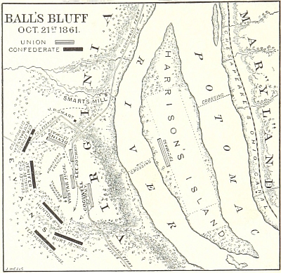
For those who are interested, here is an overview of the Battle of Ball's Bluff, fought on October 21st, 1861.
The park and battlefield have undergone restoration over the last several years to more accurately reflect its 1861 condition, and attendees will have the opportunity of touring the battlefield area and the associated National Cemetery above the Potomac River. Free Battlefield tours are conducted by expert volunteer tour guides from the group, Friends of Ball's Bluff, every Saturday and Sunday at 11AM and 1PM from early April through the end of November, so orienteers can take part in a guided tour out of the park main parking lot (not Edwards Landing) either before or after they run their courses. Tours include about one mile of walking on woodland trails and last from one to two hours. Those wishing to take tours on their own may pick up a brochure at the visitor's kiosk in the main parking lot.
Be advised that there may only be one port-a-john at Edwards Landing because of park restrictions.
Any youth or large groups attending, please contact the Event Director so that we can coordinate pre-registration for your group; the group registration and waiver form is part of the information on our Group Leaders page.
| Location | Balls Bluff Regional Park, Edwards Landing Pavilion (School Parking), Leesburg, VA (Classic) | ||||||||||||||||||||||||||||||||
| Registration | No advance registration required. Just show up and have fun! | ||||||||||||||||||||||||||||||||
| Start Times | Start any time between the specified times (usually 11am - 1:30pm). | ||||||||||||||||||||||||||||||||
| Schedule | Sunday, November 10
| ||||||||||||||||||||||||||||||||
| Volunteers |
| ||||||||||||||||||||||||||||||||
| Location Details |
| ||||||||||||||||||||||||||||||||
| Course Details | Classic
| ||||||||||||||||||||||||||||||||
| Course Notes | Classic Balls Bluff features ridge and valley terrain, which can be quite steep in places. The woods are mostly very runnable, although vegetation tends to be thicker in the northern sections. All private property (mapped as olive green color) is out of bounds. Some mapped rootstocks have decayed considerably. Many new rootstocks have appeared, and only some of them have been added to the map. The body of water on the west side of the map, just to the south of the main park entrance road, is much smaller than shown. It has shrunk to a 5m puddle. The map contour interval is 3 meters. If your route takes you atop the bluff, appreciate the great view of the river and the fall colors, but don’t get too close to the edge. The bluffs are very steep. Use caution! If you find yourself on the river near the battlefield, imagine yourself as a Union soldier attempting to cross over the Potomac to Harrison Island and safety, all the while being shot at by Confederate troops above you on the bluff. Map Scales: White/Yellow 1:5000, Orange/Brown 1:7500, Green/Red/Blue 1:10000 | ||||||||||||||||||||||||||||||||
| Entry Fees | Individual Entries
Note: juniors = under 21
Team or Group Entries Participants are welcome to compete together as a single team entry. Teams containing one or more nonmembers are charged the nonmember individual rate. Teams containing one or more adults are charged the adult individual rate. For teams to receive member or junior rates, all members of the team must be members or juniors, respectively. Each extra team map beyond the first is an additional $2. Individuals or teams desiring to compete on a second course can do so for a reduced fee of $2/map. Important Notes
|
